
Years ago while sitting through a college lecture on Iowa geology I learned of various house size boulders that lay scattered around the state, courtesy of a past glacial advance. Interesting I thought, and filed it away.
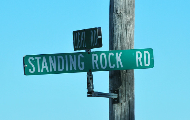
Fast forward to today. I looked for a location near Lisbon, Iowa by using a detailed map on my smartphone. The map contained names of county roads. There it was, Standing Rock Road. Suddenly the long ago college lecture came roaring back. After a quick aerial map search of the road and farm properties I came up empty with the location of the boulder. Determined to find the rock, I went to Lisbon last week, found Standing Rock Road, traveled the entire length of the road three times but the boulder remained elusive.
Finally after receiving some instructions to the boulder from the Lisbon Historical Society I located the granite structure.
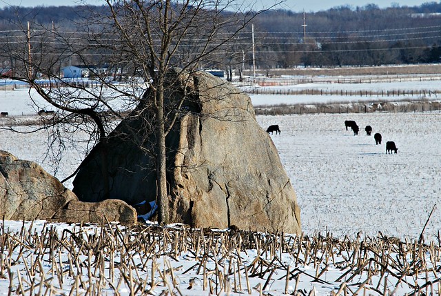
Standing Rock is located on private property in the middle of a corn field and is situated on the slope of a small hill. It is located about a mile or so west of Standing Rock Road. There must be a story there as to why the road and the structure don't more closely relate. The people at the historical society said the best time to see the rock is before planting or after harvest. Otherwise the structure is difficult to see.
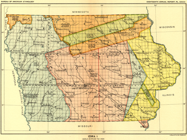
Standing Rock has been used by humans for a long time. The well rounded grey granite was purportedly used as a marker to define a boundary of the Black Hawk purchase by the U.S. federal government of lands owned by the Sac and Fox tribes in 1832. On the Iowa map (above) the Black Hawk Purchase shown in yellow. Standing Rock's location is at the apex of right facing green arrow - pointing to the yellow purchase. This long standing belief has been investigated at the National Archives collection but without actual confirmation documentation - yet. Still it is an imposing sight to see a house size boulder resting on fertile Iowa soil.
Discover Standing Rock for yourself. Take Iowa Highway 30 to Lisbon, Iowa. On the south side of town along Hwy 30 is a golf course named Hillcrest Country Club. Turn south on Country Club Drive for about a mile, then veer right on Standing Rock Road. You are traveling south on that road until it ends in a couple of miles. Turn right (west) at the T intersection at Day Road. Go about a mile and a half west. Standing Rock will be on your left a short distance from the road in a field. It is located across the road from a property filled with many old vehicles and machines. The field where Standing Rock sits is surrounded by what looks to be an electric fence. GPS coordinates: 41°52′27″N, 91°24′47″W.
Interesting. So that tree is actually huge??Hard to fathom...
ReplyDeleteWhen did the Standing Rock Grade school close?
ReplyDeleteDon, sorry for the delay. I have no idea about the closing. I bet the Lisbon History Center knows that.
ReplyDelete